
Live tracking
Drama on 08-Jul-2016
Photos of the launch
Photos of the payload during construction and testing
Telemetry schedule
Like the former flights, this one also uses a special U3S firmware version on an Arduino Nano board, with QRP Labs Si5351A Synthesiser.
Live tracking
NOTE! S-11 suffers from a bad GPS unit. The GPS unit stops reporting, when the altitude is higher than 10,000m. Due to the light weight of this payload, the design is for a flight altitude higher than 10,000m. Therefore, most of the time we are not able to receive from S-11. When it reboots in the morning when the sun comes up, the time is not set by the GPS, and neither is the location. The last known 6-character Maidenhead locator is stored in EEPROM. Since the timing is incorrect, WSPR stations don't report the transmissions. However sometimes at night the altitude falls under 10,000m, and when the morning comes it is still below 10,000m when the power reboot occurs. In this case the transmitter is able to obtain a position and synchronise its clock. Then we get WSPR transmissions but they are always showing the same position, all day. So... as of 29-Jun-2016, the S-11 flight continues but there are huge gaps between the occasionally obtained reports from the balloon.
The map below is updated automatically with the latest received position during the balloon's flight. During the balloon's night time the battery is quickly depleted, so from just after sunset there are no more reports until daylight.
Drama on 08-Jul-2016
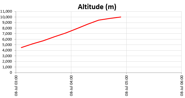
On 08-Jul-2016 the S11 balloon woke up and sent its first transmission just after 03:00Z. The GPS locked and the altitude was only 4,520m! However it turned out to be climbing, not falling! S11 must have been caught up in a high altitude cloud and been weighed down by accumulated moisture in the form of ice crystals, causing it to fall. However it apparently warmed up, thawed out, and evaporated enough to save itself before hitting the ground! It quickly climbed again until it passed through 10,000m at which point the GPS again stopped providing position etc., as usual.
This chart shows the altitude gain from the wake up just after 03:00Z. This spreadsheet download (click here) shows all the flight data to date for flight S11.
Launch


Photographs


Telemetry schedule
This is the telemetry schedule provided by Dave VE3KCL
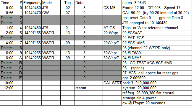
See the S-4 page for more details of the telemetry protocol. The transmission schedule for the flight is based on a 12 minute transmission cycle, commencing on the hour and repeating every 12 minutes, i.e. at 00, 12, 24, 36 and 48 minutes past each hour. A distilled version of the schedule is:
| Minute | Band | Frequency | Mode | Message |
| 00 | 30m | 10,140,480 | JT9 | Callsign VE3KCL + 6-character Maidenhead locator |
| 01 | 30m | 10,140,480 | JT9 | Altitude + groundspeed |
| 02 | 20m | 14,097,165 | WSPR | Standard WSPR message with callsign VE3KCL |
| 04 | 20m | 14,097,165 | WSPR | WSPR telemetry message on channel 4 |
| 06 | 30m | 10,140,265 | WSPR | Standard WSPR message with callsign VE3KCL |
| 08 | 30m | 10,140,265 | WSPR | WSPR telemetry message on channel 4 |
| 10 | 90 seconds of GPS calibration |
Note that the "WSPR telemetry message on channel 4" shows in WSPRnet with a callsign that has first character "0" (zero) and 3rd character "4". The remaining characters of the callsign, and the 4-character Maidenhead locator, and dBm power field, are all re-purposed for the telemetry. The WSPR decode (callsign/locator/power) will therefore be "0x4xxx xxxx xx" where the "x" is any permitted WSPR protocol character and conveys the telemetry according to the protocol discussed on the S-4 page. This special WSPR data telemetry encodes 5th and 6th Maidenhead locator, altitude, temperature, battery voltage, ground speed, GPS status and Satellite coverage.